
The White Cliffs are the first thing many visitors see of England and the last thing they see leaving it, usually from a ferry window or a coach seat. That is a shame, because the clifftop path above them is one of the best half-days out in Kent, and it does not demand any special equipment or fitness. You need a pair of shoes with grip, a windproof layer and a rough idea of which direction to walk. Here is what to expect.
The Two Routes Most People Choose
Almost every walk on the cliffs is a variation on two ideas. The short version starts at the National Trust car park at Langdon Cliffs, heads east along the top of the cliffs to South Foreland Lighthouse, and turns back. The long version carries on past the lighthouse, drops into St Margaret's Bay, climbs out again and follows the coast to Deal. Both are waymarked and both are on the Saxon Shore Way.
The short walk is the one to pick if you have children, a dog, or a train to catch. The long one is for a full day with a pub lunch at the end of it.
Route One: The Short Cliff Walk
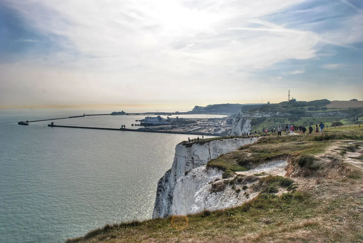
From the Langdon Cliffs visitor centre, follow the clifftop path east. It rolls rather than climbs, with a couple of short sets of steps, and within twenty minutes you get the view that makes the walk: the white wall of chalk curving away towards France, the ferry port behind you, and on a clear day the French coast as a grey smudge on the horizon.
About halfway along is Fan Bay Deep Shelter, a set of tunnels dug into the chalk during the Second World War. The steps down to it are steep and the site is not always open, so check before you build your day around it. Beyond that, the path continues to South Foreland Lighthouse, which has a small tea room and the best place on the route to sit down.
Route Two: Dover to Deal
Beyond the lighthouse the path narrows and the ground gets rougher. You drop steeply into St Margaret's Bay, a village of flint cottages tucked under the cliffs, then climb back out and follow the top of the cliffs past the Dover Patrol memorial towards Kingsdown. From there it is a flatter, gentler stretch into Deal, where you can eat, drink and either catch a bus back to Dover or collect a second car.
Allow roughly eight miles for the full route. It is a linear walk, so plan the return journey before you set off rather than at the end of a long day.
Parking and Getting There Without a Car
Parking is the part people underestimate. The National Trust car park at Langdon Cliffs is the obvious base, sitting right on the clifftop near the start of the walk. Charges apply for non-members, and on a sunny weekend in summer it can be full by mid-morning.
- Langdon Cliffs — closest to the best section of cliff, busiest, arrive early.
- St Margaret's Bay — small village parking, handy if you want a shorter walk to the lighthouse from the other direction.
- Deal or Kingsdown — park at the eastern end and walk west; quieter, and the light is often better in the afternoon.
- Dover town centre — cheaper and easier on a busy day, but adds a climb up to the cliffs at the start.
Without a car, Dover Priory station is a reasonable walk from the seafront and then uphill to the cliffs, and local buses run out to St Margaret's Bay and along the coast to Deal. Timetables change with the season, so check current times the day before.
How Long Each Walk Takes
For the short route, give yourself two to three hours from the Langdon Cliffs car park to the lighthouse and back. The walk itself is about an hour each way at a steady pace; the rest is stopping for photographs, watching the ferries and letting a child investigate every piece of chalk.
The full Dover to Deal walk takes most people four to five hours including a decent break. Wind slows you down more than you expect, and so does mud after rain. If you are walking with younger children, a good compromise is to head out for forty-five minutes, find a safe spot away from the edge for a snack, and turn around.
Timing It Right: Light, Crowds and Fog
Go early or go late. Weekday mornings outside school holidays are noticeably quieter, and an early start solves the parking problem at the same time. In summer, late afternoon and early evening give the best light: the chalk turns gold and then pink, and the path empties out.
Visibility matters more than temperature here. Sea fog can roll in and erase the whole point of the walk within half an hour, so check a forecast before you drive out, and pick a day with reasonable clarity rather than one that is merely warm. Wind is the other factor. A breezy day in the town feels like a gale on the exposed sections, and there is no shelter once you are out on the top.
Spring brings chalk grassland flowers and skylarks; autumn often has the clearest air. Winter is quiet and dramatic but the days are short and the paths muddy, so start earlier than feels necessary and carry a torch in your bag.
Before You Set Off: Practical Notes
- Wear shoes with real grip. Trainers are fine in dry weather; boots are better after rain.
- Take water and a windproof layer, even in summer. Cafés are limited, and their opening hours vary by season.
- Stay well back from the edge. Chalk crumbles and edges can be undercut. Keep dogs on a lead near the cliff and around livestock.
- Toilets are few and far between once you leave the visitor centre, so use them before you start.
- Mobile signal is patchy below the cliffs. Tell someone your route if you are doing the full walk to Deal.
- Check the National Trust site for path diversions and temporary closures before travelling.
If you have a heart condition, joint problems or any doubt about the climbs and steps, speak to your GP before attempting the longer route. The short walk is straightforward for most people; the full Dover to Deal stretch is a proper day's walking with some stiff gradients.
Above all, give it more time than you think it needs. The White Cliffs reward dawdling: a bench, a flask and twenty minutes watching the ferries slide out of the harbour is the whole point of the day.
Photo: Joshua Miranda / Pexels